June 1, 2026 — Anchorage, Alaska
- Lucian@going2paris.net

- Jun 1
- 6 min read
Courtyard by Marriott (~$500/night)
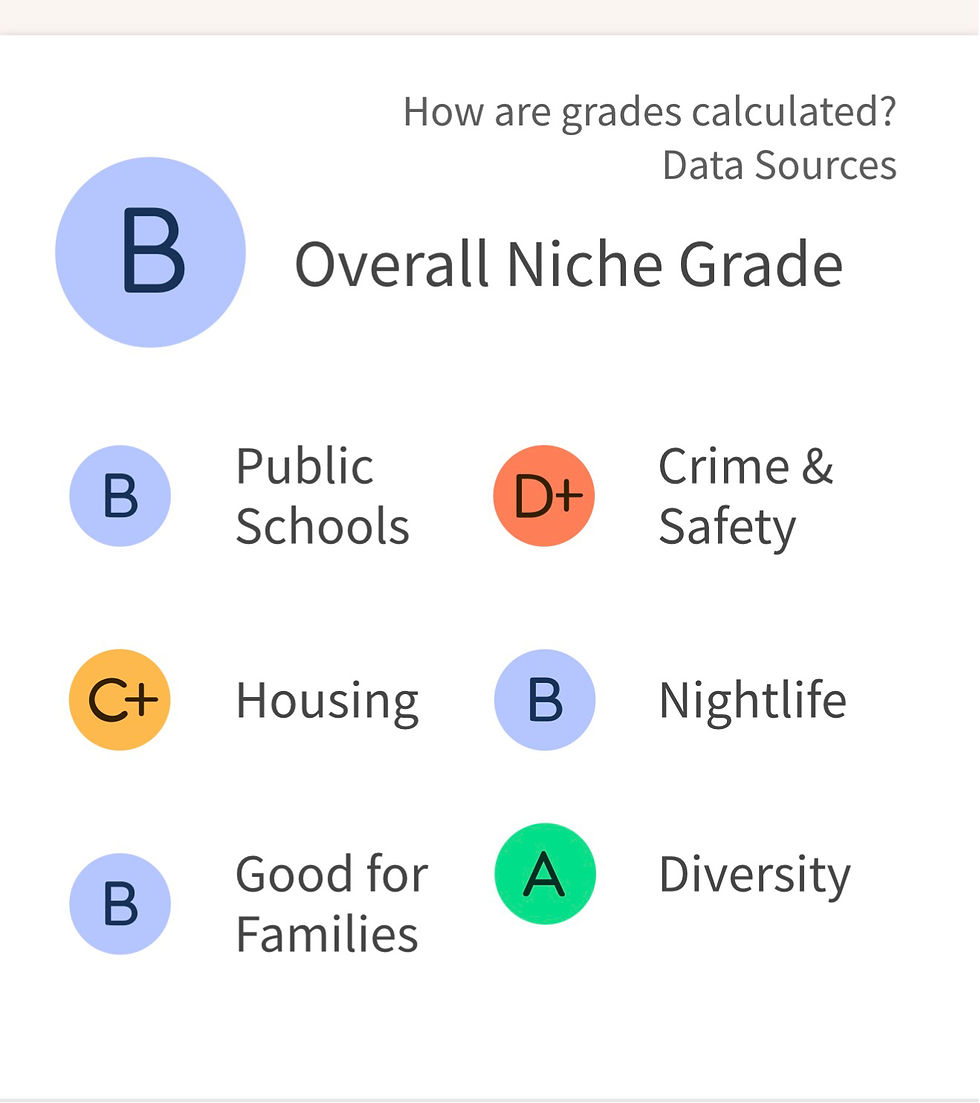
Anchorage is the most populous city in Alaska. With a population of 291,247 at the 2020 census, it contains nearly 40 percent of the state's population. The Anchorage metropolitan area, which includes Anchorage and the neighboring Matanuska-Susitna Borough, had a population of 398,328 in 2020, accounting for more than half the state's population. At 1,706 sq mi of land area, the city is the fourth-largest by area in the U.S.
Anchorage is in Southcentral Alaska, at the terminus of the Cook Inlet, on a peninsula formed by the Knik Arm to the north and the Turnagain Arm to the south. First settled as a tent city near the mouth of Ship Creek in 1915 when construction on the Alaska Railroad began, Anchorage was incorporated as a city in November 1920. In September 1975, the City of Anchorage merged with the Greater Anchorage Area Borough, creating the Municipality of Anchorage. The municipal city limits span 1,961.1 sq mi (5,079.2 km2), encompassing the urban core, a joint military base, several outlying communities, and almost all of Chugach State Park. Because of this, less than 10 percent of the Municipality is populated, with the highest concentration of people in the 260 square kilometres area that makes up the city proper, on a promontory at the headwaters of the inlet, commonly called Anchorage, the City of Anchorage, or the Anchorage Bowl.
Anchorage is almost equidistant from New York City, Tokyo, and Murmansk, Russia (straight over the North Pole). Anchorage lies within 10 hours by air of nearly 90 percent of the inhabited global north. For this reason, Ted Stevens Anchorage International Airport is a common refueling stop for international cargo flights and home to a major FedEx hub, which the company calls a "critical part" of its global network of services.
Archaeological evidence discovered at Beluga Point just south of Anchorage, along the Turnagain Arm, suggests that habitation of the Cook Inlet began 5,000 years ago by a group of Alutiiq people who arrived by kayak. As this population moved on, they were followed by a second wave of Alutiiq occupation beginning roughly 4,000 years ago, followed by a third wave around 2,000 years ago. Around 500 AD the Chugach Alutiiq were displaced by the arrival of Dena'ina Athabaskans, who entered through the mountain passes. The Dena'ina had no fixed settlements, migrating throughout the area with the seasonal changes, fishing along coastal streams and rivers in the summer, hunting moose, mountain goats, and Dall sheep in early fall, and picking berries in late fall. They tended to winter near trading junctions along common travel routes, where they traded with other Dena'ina and Ahtna tribes from nearby areas.
Captain James Cook was among the first European explorers to map the Alaskan coastline, and many of the geographical features (mountains, islands, rivers, waterways, etc.) still bear the names he gave them. Cook was searching for the fabled Northwest Passage, a route that would provide a shorter means of reaching the Pacific from Europe than the difficult Northeast Passage around the north of Asia, or south around South America. On May 15, 1778, after enduring weeks of hard weather, Cook turned into an inlet between two landmarks he called Cape Douglas and Mount St. Augustine. He anchored his ship, HMS Resolution, at a place he called "Anchor Point" (later named "Anchorage" as another Anchor Point existed to the south near Homer, Alaska), near a creek he dubbed "Ship Creek" nestled between two large arms (waterways). Cook spent ten days exploring the inlet. He first sent William Bligh to scout the north arm, where he met with the Dena'ina Natives of the Eklutna area, who told him the name of the Knik Arm and that it was not the Northwest Passage, but rather an outlet for two rivers (the Knik and Matanuska Rivers). Cook then sailed south to scout the other arm, and in a bad mood after running the Resolution aground on a sandbar on his way back out of the shallow waters, called it "River Turnagain", having found no sign of the passage there either.
In the 19th century, Russian presence in South-Central Alaska was well-established. The Russians placed trading posts along Cook Inlet, such as the Shelikhov-Golikov Company's post at Niteh on the Palmer Flats (between the Knik and Matanuska Rivers), which in turn created small agricultural communities in Ninilchik, Seldovia, and Eklutna. The Russians also introduced diseases such as smallpox that had devastating effects on the local Native population, which plummeted by half just 10 years after the first census.
In 1867, U.S. Secretary of State William H. Seward brokered a deal to purchase Alaska from Imperial Russia for $7.2 million, or about two cents an acre ($132.5 million in 2024 dollars). His political rivals lampooned the deal as "Seward's folly", "Seward's icebox" and "Walrussia". In 1888, gold was discovered along Turnagain Arm just south of modern-day Anchorage, leading to a new influx of prospectors, and small towns such as Spenard, Hope, Rainbow, Bird, Indian, and Girdwood began to spring up.
Alaska became an organized incorporated United States territory in 1912. Anchorage, unlike every other large town in Alaska south of the Brooks Range, was neither a fishing nor mining camp. The area surrounding Anchorage lacks significant economic metal ores. A number of Dena'ina settlements existed along Knik Arm for years. By 1911 the families of J. D. "Bud" Whitney and Jim St. Clair lived at the mouth of Ship Creek and were joined there by a young forest ranger, Jack Brown, and his bride, Nellie, in 1912.
The city grew from its happenstance choice as a site for railroad construction to begin in 1914. The waters near Ship Creek were deep enough for barges and small ships to dock, and under the direction of Frederick Mears, it became a railroad-construction port for the Alaska Engineering Commission. The area near the mouth of Ship Creek, where the railroad headquarters was, quickly became a tent city. Anchorage formed at a time when proponents of Prohibition were gaining traction, and as part of an effort to stem the flow of the alcohol trade, at the direction of President Woodrow Wilson and with the symmetry of the US Army, a town site was mapped out on higher ground to the south of the tent city, with the condition that a person's land could be repossessed if caught breaking the alcohol laws. Anchorage has been noted in the years since for its order and rigidity compared with other Alaska town sites. In 1915, territorial governor John Franklin Alexander Strong encouraged residents to change the city's name to one that had "more significance and local associations". In the summer of that year, residents held a vote to change the city's name; a plurality favored the name "Alaska City", but the territorial government ultimately declined to change the city's name. Anchorage was incorporated on November 23, 1920.
Construction of the Alaska Railroad continued until its completion in 1923. The city's economy in the 1920s and 1930s centered on the railroad. Colonel Otto F. Ohlson, the Swedish-born general manager of the railroad for nearly two decades, became a symbol of residents' contempt due to the firm control he maintained over the railroad's affairs, which by extension became control over economic and other aspects of life in Alaska.
2020 census
At the 2020 census, Anchorage had 291,247 people. Racial makeup was 63.8% White, 10.0% Asian, 9.1% American Indian or Alaska Native, 6.0% African American, and 8.4% from two or more races; 9.4% of the people were Hispanic or Latino. The age distribution was 6.9% of the population under the age of 5; 24.0% under 18; 64.3% aged 18–64; and 11.7% aged 65 and up. 50.9% of residents were male; 49.1% were female. Veterans were 9.3% of all residents and 10.9% of residents born outside the United States.
There were 119,276 housing units and 106,567 households; the average household size was 2.69 persons. In 17.8% of households, a language other than English was spoken at home. 95.9% of households had a computer; 90.0% of households had broadband Internet connections. 93.9% of the population had a high school diploma or higher, and 36.1% had a Bachelor's degree or higher. 8.4% of the population under the age of 65 had a disability with 11.1% of the same age group having no health insurance. 68.5% of the population were in the civilian labor force. The median household income was $84,928 and the per capita income from May 2019 – April 2020 was $41,415. The poverty rate was 9.5%.
Comments