
Fairfield Inn
Goshen, Indiana
May 22, 2022

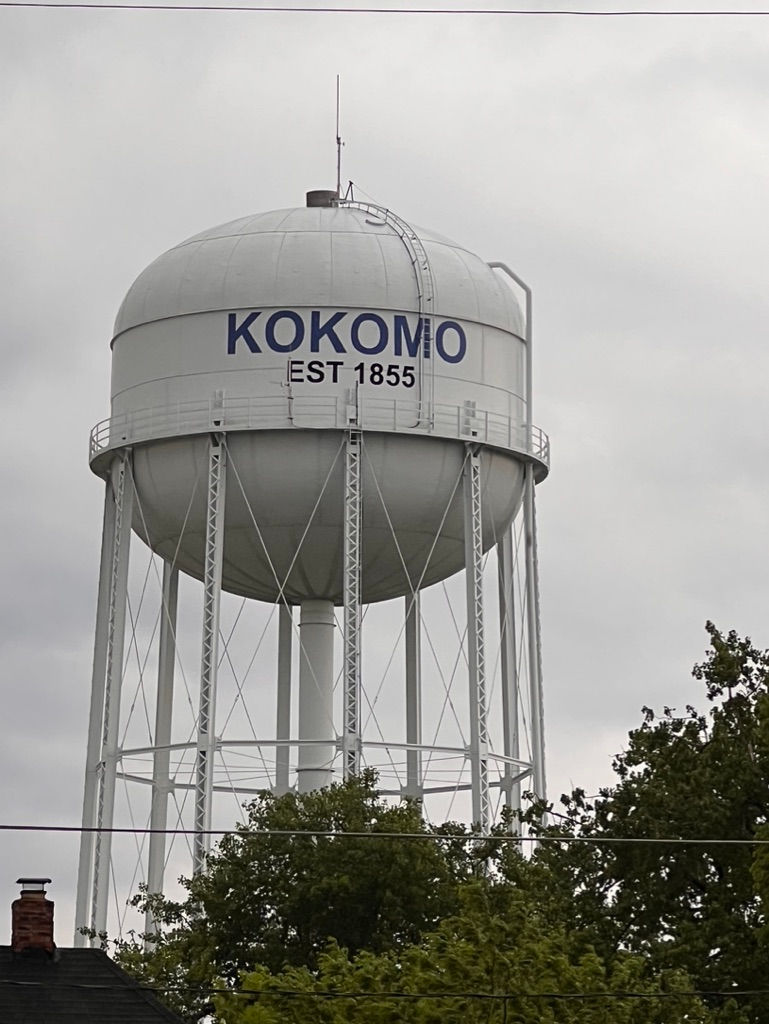
My day started out waking up in the Walmart parking lot in Kokomo. This is not the Kokomo from the Beach Boys song.
Kokomo (/ˈkoʊkəmoʊ/ KOH-kə-moh) is a city in Indiana and the county seat of Howard County. It is the principal city of the Kokomo, Indiana Metropolitan Statistical Area, which includes all of Howard County, the Kokomo-Peru CSA, which includes Howard and Miami counties, as well as the North Central Indiana region [6] consisting of six counties anchored by the city of Kokomo. Kokomo's population increased from 45,468 at the 2010 census to 59,604 in the 2020 census.
Named for the Miami Ma-Ko-Ko-Mo who was called "Chief Kokomo", Kokomo first benefited from the legal business associated with being the county seat. Before the Civil War, it was connected with Indianapolis and then the Eastern cities by railroad, which resulted in sustained growth. Substantial growth came after the discovery of large natural gas reserves, which produced an economic boom in the mid-1880s. Among the businesses which the boom attracted was the fledgling automobile industry. A significant number of technical and engineering innovations were developed in Kokomo, particularly in automobile production, and, as a result, Kokomo became known as the "City of Firsts." A substantial portion of Kokomo's employment still depends on the automobile industry.
History
Early history and incorporation
The settler tradition says Kokomo was named for Kokomoko or Ma-Ko-Ko-Mo (meaning "black walnut"), shortened to Kokomo, said to have been one of the four sons of Chief Richardville last of the chiefs of the Miami people. Folklore holds that he was 7 feet (2.1 m) tall and falsely gives him the title of "chief." David Foster, known as the "Father of Kokomo," claimed that he named the town Kokomo after the "ornriest Indian on earth" because Kokomo was "the ornriest town on earth." Kokomo is thought to have been born in 1775 and died in 1838. The only documentary proof of his existence is a trading post record of a purchase of a barrel of flour for $12 for his "squaw." His remains (with those of others) were reportedly discovered during the construction of a saw mill in 1848 and re-interred in the "north-east corner" of the Pioneer Cemetery. The tradition of the Peru Miami is that the town was named after a Thorntown Miami named Ko-kah-mah, whose name is rendered Co-come-wah in the Treaty at the Forks of the Wabash in 1834. That name was translated as "the diver" (an animal that could swim under water).
As a result of various removals, by 1840 the Miami population in Howard County (until 1846 known as Richardville County) was reduced to about 200. The principal settlement was the Village of Kokomo, on the south side of Wildcat Creek. Indian paths connected Kokomo with Frankfort and Thorntown (along the Wildcat) and led to Peru by way of Cassville, and to Meshingomesia by way of Greentown. At the time David Foster had a trading post in Howard County, near the intersection of the reservation boundary line and Wildcat pike, where he engaged in both legitimate trade and illegal sale of alcohol to the Miamis on government property.
Shortly after Richardville County was organized in 1844 the commissioners appointed to establish the county seat approached Foster for a donation from his substantial holdings. (In 1846 tax records show that he owned 552 acres (223 ha) of farmland and as well as 67 divided lots in the business district.) At the time of the request the only improvements in what is now Kokomo were Foster's log house and log barn and several Miami huts. The commissioners sought a donation of the more fertile lands south of Wildcat Creek, but Foster refused, donating instead 40 acres (16 ha) north of the creek—land which was thickly forested and "swampy." The terms of the donation required that Foster build a courthouse on the land, but he was later excused and Rufus L. Blowers was promised $28 to build it. He was penalized $2 for construction delays. The log courthouse was completed in 1845.
In June 1855 Henry A. Brouse petitioned the board of Howard county commissioners to incorporate the town of Kokomo. The original election was not held (for unspecified reasons), but another took place on October 1, 1855. After a vote of 62–3 in favor of incorporation, the board so ordered it.
On March 31, 1865, an election was held for Kokomo to assume a city government. The resolution was passed, and Nelson Purdum was elected the first mayor.
Early growth
In anticipation of business that the court would bring, Kokomo began a fairly quick growth from the time that lots were first sold on October 18, 1844. David Foster was granted the first license to sell merchandise in Kokomo at the December 1844 commissioners meeting. Two more merchants were licensed in March 1845. John Bohan, who would become a major shop owner, merchant, justice of the peace and investor, moved to Kokomo in December 1844, and erected the first two-story frame house, not only in Kokomo, but in all the county.
After the enactment of the 1846 pre-emption law, settlers rapidly attempted to secure homesteads in the surrounding lands.
In 1848 Stonebreaker's Mill, 10 miles (16 km) west of Kokomo, began operations. By 1850 Kokomo had a newspaper, when James Beard purchased the printing equipment of the New London Pioneer and set up the Howard Tribune. By 1851 county business was so brisk that the county ordered the construction of two more court buildings, both one story brick affairs, 18 by 36 feet (5.5 by 11.0 m). The county auditor and treasurer occupied one building, and the clerk and recorder occupied the other.
On April 1, 1854, Kokomo's first bank, the Indian Reserve Bank, was organized with David Foster, John Bohan and Harless Ashly the principal shareholders. (It only lasted a few years until a robbery impaired its capital. The loss substantially injured Foster's fortune.)
Railroads
1854 saw the first railroad stop at Kokomo. The New London Pioneer had long advocated for a rail line to connect Kokomo with Indianapolis. Colonel C.D. Murray was the agent at Kokomo for stock subscriptions in support of the railroad. In 1852 the construction of the Peru and Indianapolis Railroad commenced. In Kokomo Samuel C. Mills and Dr. Corydon Richmond, commercial competitors of David Foster, donated several lots to the railroad in order to secure the location of the rail depot near their commercial property. The route was laid along Buckeye Street at the insistence of the merchants who hoped to reduced drayage expenses. Samuel Mills built a large frame structure at the Howard flouring mills, which served as a warehouse for the company's freight and a passenger depot. For some time after 1854 Kokomo was the terminus of the line, but eventually the line was extended to Peru and then to Michigan City.
A short time after the construction of the Peru and Indianapolis Railroad began, the Pennsylvania Railroad announced that one of its lines would pass through Kokomo. By 1853 a line was commenced between Kokomo and Logansport (which was intended to become the hub of a network of lines for the company). Railroad service was inaugurated on that line on July 4, 1855.
The most important rail line for Kokomo became the standard-gauge Clover Leaf line. This railroad would eventually link Kokomo with both the West Coast and the Eastern Seaboard. It began as a short line linking Frankfort and Kokomo, the Frankfort and Kokomo Railroad. Henry Y. Morrison of Frankfort was the principal promoter, and A.Y. Comstock acted for him in Kokomo. A failure of the proposed subsidy caused the promoters to turn all assets over to the contractors, who promised to complete the line. Construction began in 1873 and was completed the following year. Limited freight between the two cities made the line unprofitable. After a series of acquisitions by other railroads, the line became part of the Toledo, St. Louis and Kansas City Railroad. A line connecting it to the east reached Kokomo on January 1, 1881.
Mayor Cole
In 1881, one of the most remarkable and controversial events in Kokomo's history took place. Mayor Henry C. Cole was shot to death by a sheriff's posse. Dr. Cole had a curious history and had stirred up a great deal of passion in the previous fifteen years. He was reputed to have been a gifted surgeon, who served in the Union Army during the Civil War and when afterwards he settled in Kokomo, he became a prominent physician. In Kokomo he married a woman, Natalie Cole, of whom he became intensely jealous. He became suspicious of one Allen, whom he warned away from Kokomo. When he discovered Allen leaving the post office one day in October 1866, he shot him dead. The fact that the killing both took place in broad daylight and showed cold-blooded rage (Cole continued shooting after Allen was down) caused the crime to receive national attention. Cole's case was venued to Tipton County, where he retained Daniel W. Voorhees of Terre Haute to represent him. Voorhees obtained a not guilty verdict on a plea of emotional insanity. Cole divorced his wife thereafter.
Cole's reputation for violent instability, and the cowardice in the way he killed Allen, created many enemies for him, but his generosity toward poor patients and a promise to "clean up" the town won him enough support to win a bitter election for Mayor in 1881. Shortly thereafter, on September 19, 1881, he was shot dead by a sheriff's posse at Old Spring Mills at West Jefferson Street. According to the coroner's inquest, he died from shotgun wounds inflicted by Deputy George Bennett (father of New York stage idol Richard Bennett). The sheriff claimed that an informant had advised him that Cole was planning to rob a flour mill, possibly to incriminate his enemies. The posse was forced to fire on Cole in self-defense (the sheriff claimed he had two revolvers) and to prevent his escape, although his injuries seemed inconsistent with that version. Cole's supporter's argued that no revolvers or burglary tools were produced and that the motive was implausible. Nevertheless, no action was taken against Bennett or the other members of the posse.
Natural gas miners and their drill, near Kokomo, Indiana during the Indiana Gas Boom, c. 1885
Natural gas boom
Natural gas had been developed in Pennsylvania and Canada for some time, and had most recently been developed around Findlay, Ohio. In March 1886, a group of citizens, led principally by A.Y. Comstock (who had promoted the Frankfort and Kokomo Railroad) and D.C. Spraker (later President of Kokomo Rubber Company), circulated a memorandum seeking subscribers (at $100 each) for the purpose of boring for gas at a distance of at least 2,000 feet (610 m) below ground. It took until September to obtain the necessary 22 subscribers. The first rig was built south of Wildcat Creek. and on October 6, 1886, natural gas erupted forth and the well was capped.
Together with the well in Eaton, which began producing slightly before Kokomo's, the discovery led to the Indiana Gas Boom. This discovery was directly responsible for Elwood Haynes' move to Kokomo, as a superintendent with a gas company with interests in Kokomo and Howard County. The Diamond Plate Glass Company (now part of PPG Industries) began in Kokomo in 1887, lured by the cheap and plentiful natural gas. The Kokomo Opalescent Glass Works started making stained glass in Kokomo in 1888 and has been in continuous operation ever since.
"City of Firsts"
As a result of the natural gas boom, Kokomo attracted an increasing number of industries, which resulted in significant technological innovations. For these industrial and technical achievements, Kokomo is officially known as the "City of Firsts." Among other achievements, Kokomo was a pioneer of the United States automobile manufacturing, with Elwood Haynes test-driving his early internal combustion engine auto there on July 4, 1894. Haynes and his associates built a number of other autos over the next few years; the Haynes-Apperson Automobile Company for mass-production of commercial autos was established in Kokomo in 1898. Haynes went on to invent Stainless Steel flatware in 1912 to give his wife tarnish-free dinnerware.[43] In 1938, the Delco Radio Division of General Motors (now Aptiv) developed the first push button car radio.
Kokomo serves as the "City of Firsts" in the food industry as well. In 1928 Walter Kemp, Kemp Brothers Canning Co. developed the first canned tomato juice because of a request by a physician in search for baby food for his clinic. Kokomo is also home to the first mechanical corn picker which was developed by John Powell in the early 1920s. Kokomo was home to the first Ponderosa Steakhouse, which opened in 1965. Kokomo opened the first McDonald's with a diner inside, locally called "McDiner."This McDonald's theme failed nationally. Eventually, the "McDiner" closed and was converted back to a regular McDonald's restaurant.
The following inventions are associated with Kokomo:
1894 – Elwood Haynes makes the first successful trial run of his "horseless carriage" on Pumpkinvine Pike, which is now Boulevard east of Indiana 931 (formerly U.S.31.)
1894 – The first pneumatic rubber tire in the US was created by D.C. Spraker at the Kokomo Rubber Tire Company.
1895 – The first aluminum casting was developed by William "Billy" Johnson from the Ford and Donnelly Foundry.
1902 – Kingston carburetor developed by George Kingston.
1906 – The first Stellite cobalt-base alloy was discovered by Elwood Haynes.
1912 – Stainless steel tableware was invented by Elwood Haynes as a response to his wife's desire for tableware that wouldn't tarnish.
1918 – The Howitzer shell, used in World War I, was created by the Superior Machine Tool Company.
1918 – The first aerial bomb with fins was produced by the Liberty Pressed Metal Company.
1920 – The mechanical corn picker was created by John Powell.
1923 – William Swern Sr. developed the first tire-building machine for mass production of auto tires [48][49]
1928 – The first canned tomato juice was created by Walter Kemp from Kemp Brothers Canning Company in response to a physician's need for baby food.
1938 – The first push-button car radio was created at Delco Radio Division of General Motors Corporation.
1941 – Globe American Stove Company manufactured the first all-metal life boats and rafts, known as Kokomo Kids in the US Navy.
1947 – The first signal-seeking car radio was created by the Delco Radio Division of General Motors.
1956 – Delco Radio Division of General Motors produced a transistorized signal-seeking car (hybrid) radio, which used both vacuum tubes and transistors in its radio's circuitry. This transistorized car radio was available as an option on the 1956 Chevrolet Corvette car models.[50][51]
1957 – Delco Radio Division of General Motors produced an all-transistor car radio, as standard equipment for the Cadillac Eldorado Brougham car model.[52][53][54]
1913 Flood
On March 21–26, 1913 Kokomo suffered severe flooding when 6.59 inches (167 mm) of rainfall occurred. The Kokomo Tribune reported at the time that the Wildcat Creek over-topped its levee to reach nearly 1 mile (1.6 km) wide after rising at a rate of 3 inches (76 mm) per hour. Damage was widespread, including loss of electrical power due to the power plant being flooded. On March 26, flooding was declared over after the water level dropped 42 inches (1,100 mm) in a 24-hour period.
Ku Klux Klan
In the summer of 1923, record numbers attended rallies of the Ku Klux Klan in Indiana. On June 16, 1923, a crowd of 75,000 attended a Klan rally in Terre Haute. On June 21 Argos held the largest rally it had ever seen.[57] On June 26 a large Klan rally was held in Alexandria. All of this was merely a prelude to the rally planned for Kokomo. Conceived as a "monster tristate conclave," it was intended to charter 93 Indiana klans representing more than 300,000 members.[58] Some doubted the prospect of 200,000 attendees, claiming it would be "without parallel in history";[59] others predicted attendance of 300,000.[60] Extensive preparations for that number were made, including the scheduling of 1,000 interurban cars from around Indiana to Kokomo.[61] The Union Traction Company, in addition to supplying 50 cars, transported three cars of white horses to Kokomo for the parade.[62] The Kokomo Klan rented the fields surrounding its own large lot for parking, and electric amplifiers were obtained to allow the large crowd to hear the speeches.[60]
According to historian Robert Coughlan, "literally half" of Kokomo residents were members of the Ku Klux Klan during its height in the 1920s and 1930s.[63] On July 4, 1923, Kokomo achieved national notoriety when it hosted the largest Ku Klux Klan gathering in history. An estimated 200,000 Klan members and supporters gathered in Malfalfa Park for a massive Konklave in which D. C. Stephenson was elevated to the position of Grand Dragon of the Indiana Klan.[64][65] Other estimates say the crowd was only 10,000.[66] A huge flag was used that day to collect a reported $50,000 for construction of a local "Klan hospital" so that Klan members would not have to be treated at the only local hospital, which was Catholic.[67] Both men's and women's Klans held weekly rallies and initiations in Malfalfa Park, and Kokomo's Klanswomen held meetings at the armory, the local headquarters of the Women of the Ku Klux Klan, and churches. A speech at a Baptist church was attended by 1,000 Klanswomen.[68]
The Kokomo rally sent shockwaves through the national GOP, which had come to believe that the re-election of President Warren G. Harding depended on the vote of Indiana. According to the Washington correspondent of the New York World, Republicans feared that the Klan had "virtually swallowed" the Indiana Republican Party. Since the Republicans held only a 25,000 vote plurality in the state, any serious defection of African-Americans would tip the state to the Democrats.[69] In the event, Harding died within a month and Republican Calvin Coolidge succeeded him with a substantial electoral majority (including Indiana) against a divided opposition. The Klan, however, continued to dominate state politics especially after the election of Edward L. Jackson as governor.
1965 tornado
On April 11, 1965, the southern part of Kokomo was struck by one of the 47 tornadoes that erupted over six Midwestern states, an event now known as the Palm Sunday outbreak.[70] The F4 tornado that swept through Kokomo was 800 yards (730 m) wide and killed 25 people in the surrounding area.[71] Significant damage was done to the Chrysler transmission plant. Windows were broken and the framework cracked throughout, and sections of the west wall were leveled. The Maple Crest elementary and junior high schools suffered extensive damage. The roof collapsed on the junior high school, and the framework of both schools was substantially wrecked. The Maple Crest Shell Station at the intersection of Lincoln and Washington was torn from its foundation and scattered about. Mills Drug Store at the same intersection was demolished. A house on Holly Lane was uprooted, and one on James Drive was demolished. The Maple Crest Shopping Center was extensively damaged, with Woolworth's suffering the most damage. The front and back of the one-story structure were caved in and merchandise was strewn about.[72] Numerous homes in the Maple Crest area were flattened, and the top floor of the Maple Crest apartments was blown off. The only thing left standing on the nearby Church of the Brethren was the steeple.[73] The force of the wind on the flat earth near Kokomo was so great that Ted Fujita was able to make aerial photographs of the spiral scoring on the ground.
Ryan White[edit]
Kokomo served to symbolize the nation's early misunderstanding and ignorance of AIDS in the mid-to-late 1980s when Ryan White was expelled from school due to his illness. White was a teenage hemophiliac who had been infected with HIV through contaminated blood products (Factor 8). At the time blood products were often collected through state prison systems. Factor 8 was made from pooled plasma of thousands of donors. Later the plasma was screened for HIV and Hepatitis and heat treated to inactive HIV and Hepatitis. The teen had been attending Western Middle School (which is actually in Russiaville) but was ostracized by his classmates, and forced to eat lunch alone and use a separate restroom. Many parents and teachers in Kokomo rallied in support of banning White from attending the school. A lengthy administrative appeal process with the school system ensued, followed by death threats and violence against White and his family, including a bullet being fired through the window of their Kokomo home. Media coverage of the case made White into a national celebrity and spokesman for AIDS research and public education.[75] In 1987, the White family left Kokomo for Cicero, Indiana. Ryan attended Hamilton Heights High School in nearby Arcadia, where he was welcomed by faculty and students.
Gas tower
The Kokomo Gas Tower had been a symbol of Kokomo since it was constructed in 1954. The tower was 378 feet (115 m) tall and had a capacity of 12,000,000 cubic feet (340,000 m3). Due to high maintenance costs of $75,000 a year, and up to $1,000,000 to paint it, the gas company decided to demolish it in 2003. Other ideas were reviewed before settling on this decision, including a plan to turn the tower into a giant Coca-Cola advertisement. On September 7, 2003, at approximately 7:30 a.m., the Gas Tower was demolished by Controlled Demolition, Inc. (CDI). Pieces of the tower were sold to the public for $20–$30, and proceeds went to a planned Kokomo technology incubation center and Bona Vista.[76]
2016 tornado
On August 24, 2016, a strong EF3 tornado caused major damage in the southern part of Kokomo. 1,000 homes were damaged, 170 of which sustained major damage. 80 of these homes were destroyed, some sustaining loss of roofs and exterior walls. Many large trees and power poles were snapped along the path, and the Park Place Apartments were heavily damaged as well. Vehicles were also damaged, including a large truck that was moved 10 feet from the driveway of a house and flipped over.[77] A Starbucks was completely destroyed, and several people were left trapped inside the still standing bathroom and had to be rescued.[78] Many sheds and detached garages were destroyed as well, and a receipt from Kokomo was found 30 miles away in Marion.[77] The storm followed a path very close to that of another tornado which hit on November 17, 2013. Scientists have noticed that nearly every tornado in Kokomo has struck the southern part of the city.[79]
Environmental problems
Continental Steel Corporation
From 1914 through 1986, the Continental Steel Corporation facility produced nails, wire and wire fence from scrap steel on a 183-acre (74 ha) facility in Kokomo. Manufacturing operations in the steel plant and on other portions of the property included the use, handling, storage and disposal of hazardous materials. Steel-making operations had included reheating, casting rolling, drawing, pickling, galvanizing, tinning and tempering.
After the company filed for bankruptcy in 1986, EPA and the Indiana Department of Environmental Management investigated the plant and property and found soil, sediments, surface water and ground water contaminated with volatile organic compounds (PCBs) and several metals, including lead, arsenic, cadmium, and chromium. Lead contamination was also detected in soils on nearby residential properties.
The site was proposed to the National Priorities List as a Superfund site in 1988 and formally added in 1989.[84]
In April 2009, EPA received almost $6 million in American Recovery and Reinvestment Act to complete needed cleanup at two problems at the Continental Steel Superfund site: the former Slag Processing Area and the site's contaminated ground water. The ARRA funding helped accelerate the cleanup of hazardous waste on the site. In the process, total of 15 Indiana contractors or subcontractors were involved in the ARRA-funded work, creating at least 45 temporary jobs.
In August 2010, using the ARRA funds, EPA completed the cleanup of the former slag processing area of the Superfund Site. Approximately 86,000 short tons (78,000 t) of slag were moved to the site's acid lagoon area for use as fill on that portion of the site. Two feet (0.6 m) of clean soil were used to cap the former slag processing area, leaving it suitable for potential redevelopment. ARRA funds were also used to address contaminated groundwater at the site. This work included extensive groundwater sampling to determine the contaminated plume area and installation of groundwater extraction and monitoring wells. Three wind turbines will be used to generate much of the power needed to operate the groundwater extraction system.
Site cleanup was completed in August 2011.[85]
In 2016 the former site was approved as the location of a Solar farm with installation of panels beginning in August 2016. The estimated cost of the project is $10M.[86] The solar energy park began operating on December 29, 2016.[87]
Groundwater contamination
In 1995 the Indiana American Water treatment facility found groundwater beneath the city contaminated with trace amounts of vinyl chloride. In 2007, the Indiana Department of Environmental Management found groundwater at four municipal wells containing vinyl chloride at levels exceeding the EPA maximum contaminant level in raw water.[88]
In 2011, it found one of the monitoring wells, not owned or used by Indiana American Water, had amounts of vinyl chloride that were more than 2,500 times the maximum level for drinking water.[88] IDEM has identified fourteen facilities that handle chlorinated solvents and could be sources to the contamination plume. Some of these potential sources are currently being managed under other authorities but there is no cleanup approach focusing on the ground water plume. Water from several well fields in Kokomo are blended and treated prior to distribution. A water treatment system has been successfully removing the vinyl chloride from the finished drinking water, but this is not a permanent solution to address the contaminated ground water plume.
The site was proposed to the National Priorities List and added to the Superfund in March 2015. No cleanup plan is yet in effect.[89]
Economy
Kokomo's employment, largely based in manufacturing, was hard hit by the economic downturn which led to the recession beginning in December 2007.[citation needed] In December 2008, Kokomo was ranked third by Forbes in its list of America's fastest dying towns, mainly as a result of the financial difficulties of the automotive industry.[98]
In May 2011, Forbes magazine listed Kokomo as one of the "Best Cities for Jobs" after the city ascended 177 places in the rankings. The same article described Kokomo's success in the past few years as "inspirational" and attributed the turnaround to "a revival in manufacturing."[99] In June 2011, Conexus released a report touting Kokomo's "rapid bounce" after the recession, and predicted a rise in income of more than 2%, assuming increased automobile production.
By May 2013 Kokomo's unemployment rate was 9%, representing a 1.4% decrease in non-farm employment,[101] it was higher than the national rate of 7.6%.[102] The May 2013 statistics reported a 6.9% decline in manufacturing jobs over the previous 12 months. Government employment was 18.7% below the previous year.[101]
Major employers are
Chrysler Division of Stellantis
Aptiv
BorgWarner
GM Components Holdings LLC
Haynes International
Holder Mattress
Syndicate Sales, Inc.
Coca-Cola bottling plant
Bona Vista (charity)
Fox is an unincorporated community in Pleasant Township, Grant County, Indiana. Fox was named for Edward Fox, a local settler.[3] A post office was established at Fox in 1884, and remained in operation until it was discontinued in 1906. Fox is located at 40°38′23″N 85°41′42″W.
Wabash is a city in Noble Township, Wabash County, in the U.S. state of Indiana.[4] The population was 10,666 at the 2010 census. The city is the county seat of Wabash County.[5]
Wabash is notable as claiming to be the first electrically lighted city in the world, which was inaugurated on March 31, 1880. However, closer inspection of the reference shows only the court house grounds were lighted.[6] It is also home to the historic Eagles Theatre, Paradise Spring Treaty Grounds (1826), the Wabash and Erie Canal, Presbyterian Church (1880), and Disciples of Christ Christian Church (1865).
The name Wabash derives from a Miami-Illinois term for "water over white stones."[9] The Wabash post office has been in operation since 1839.[10][11] The Miami name reflected the clarity of the river in Huntington County, Indiana where the river bottom is limestone.[12]
Wabash used a new type of carbon arc light invented by Charles Brush in 1870. On March 31, 1880, four 3,000-candle power lamps were suspended from the top of the courthouse. Two telegraph wires ran from the lamps to the courthouse basement, where they were connected to a generator powered by a 12-horsepower steam engine to provide power.
Warsaw is a city in and the county seat of Kosciusko County, Indiana, United States.[4] Warsaw has a population of 13,559 as of the 2010 U.S. Census. Warsaw also borders a smaller town, Winona Lake.
Etymology[edit]
Warsaw, named after the capital of Poland in tribute to Tadeusz Kościuszko, was platted on October 21, 1836.[5] Warsaw's post office was established in 1837.[6]
History[edit]
Early Warsaw saw traders, trappers, and merchants supplying manufactured goods to area farmers. Because of the central location in the lake region, tourists soon began visiting Warsaw and eventually made permanent residences in the city, with industry soon following.
In March 1854, Warsaw became a town, and the initial census on February 2, 1854, showed a total of 752 residents in the town limits. The Pennsylvania Railroad (then known as the Pittsburgh, Fort Wayne, and Chicago Railroad) reached Warsaw in November 1854. The Big Four Railroad (Cleveland, Cincinnati, Chicago, and St Louis) arrived in Warsaw in August 1870.
Gas lights were installed in August 1880. Telephone lines were strung in 1882, with Dr. Eggleston having the first phone. The waterworks were constructed in 1885. Gas was supplemented with electricity in 1897, but gas was still used in many homes until 1915.
In 1895, Revra DePuy founded DePuy Manufacturing in Warsaw to make wire mesh and wooden splints, becoming the world's first manufacturer of orthopedic appliances. In 1905, DePuy hired Justin Zimmer as a splint salesman. Zimmer broke away from DePuy in 1927 to start his own orthopedic company with Joe Ettinger in the basement of Ettinger. Warsaw is now known as the "orthopaedic capital of the world."[7][8]
The Warsaw-based East Fort Wayne Street Historic District, Kosciusko County Jail, Warsaw Courthouse Square Historic District, Warsaw Cut Glass Company, and Justin Zimmer House are listed on the National Register of Historic Places.[9]
Geography[edit]
Warsaw is located at 41°14′26″N 85°50′49″W (41.240564, -85.847002)[10] and occupies the area between Pike Lake, Hidden Lake and Center Lake (to the north) and Winona Lake (to the southeast). The Tippecanoe River passes through the West portion of Warsaw. U.S. Route 30 and Indiana State Road 15 both pass through town, while Indiana State Road 25 begins on West Market Street while traffic is routed to West Winona Avenue along with State Road 15 after US Route 30 bypassed the downtown area.
According to the 2010 census, Warsaw has a total area of 12.918 square miles (33.46 km2), of which 11.58 square miles (29.99 km2) (or 89.64%) is land and 1.338 square miles (3.47 km2) (or 10.36%) is water.[11]
Transportation[edit]
Airport[edit]
KASW - Warsaw Municipal Airport
Demographics[edit]
2010 census[edit]
As of the 2010 U.S. Census,[12] there were 13,559 people, 5,461 households, and 3,311 families living in the city. The population density was 1,170.9 inhabitants per square mile (452.1/km2). There were 6,066 housing units at an average density of 523.8 per square mile (202.2/km2). The racial makeup of the city was 89.5% White, 1.6% African American, 0.5% Native American, 2.2% Asian, 4.3% from other races, and 2.0% from two or more races. Hispanic or Latino of any race were 10.4% of the population.
There were 5,461 households, of which 32.1% had children under the age of 18 living with them, 43.1% were married couples living together, 12.8% had a female householder with no husband present, 4.7% had a male householder with no wife present, and 39.4% were non-families. 32.8% of all households were made up of individuals, and 11.7% had someone living alone who was 65 years of age or older. The average household size was 2.38 and the average family size was 3.02.
The median age in the city was 34.8 years. 25.2% of residents were under the age of 18; 9.2% were between the ages of 18 and 24; 28.2% were from 25 to 44; 24% were from 45 to 64; and 13.4% were 65 years of age or older. The gender makeup of the city was 49.1% male and 50.9% female.
2000 census[edit]
As of the 2000 U.S. Census,[3] there were 12,415 people, 4,794 households, and 3,068 families living in the city. The population density was 1,184.6 people per square mile (457.4/km2). There were 5,101 housing units at an average density of 486.7 per square mile (187.9/km2). The racial makeup of the city was 70.50% White, 1.41% African American, 0.39% Native American, 1.07% Asian, 0.02% Pacific Islander, 5.25% from other races, and 1.37% from two or more races. Hispanic or Latino of any race were 29.21% of the population.
New county courthouse building.
There were 4,794 households, out of which 32.4% had children under the age of 18 living with them, 49.0% were married couples living together, 10.8% had a female householder with no husband present, and 36.0% were non-families. 30.4% of all households were made up of individuals, and 11.8% had someone living alone who was 65 years of age or older. The average household size was 2.49 and the average family size was 3.11.
In the city, the population was spread out, with 26.0% under the age of 18, 10.9% from 18 to 24, 29.0% from 25 to 44, 21.0% from 45 to 64, and 13.2% who were 65 years of age or older. The median age was 34 years. For every 100 females, there were 97.3 males. For every 100 females age 18 and over, there were 93.3 males.
The median income for a household in the city was $36,564, and the median income for a family was $45,153. Males had a median income of $33,322 versus $22,284 for females. The per capita income for the city was $19,262. About 6.8% of families and 9.2% of the population were below the poverty line, including 8.7% of those under age 18 and 13.4% of those age 65 or over.
Government[edit]
Old Kosciusko County Courthouse.
Warsaw has an elected mayor, clerk and city council-style of government. Officials are elected for four-year terms. Warsaw's current mayor is Republican Dr. Joseph Thallemer, who has served since January 1, 2012. Mike Hodges is Warsaw's longest-serving mayor who served for 5 terms.
Representatives - common council[edit]
The Warsaw Common Council is a seven-member legislative group that serve four-year terms. Five of the members represent specific districts; two are elected citywide as at-large council members.
Jack Wilhite: At-large
Cindy Dobbins: At-large
Jeff Grose: 1st district
Ron Shoemaker: 2nd district[13]
Mike Klondaris: 3rd district
William "Jerry" Frush: 4th district
Diane Quance: 5th district
Lynne Christiansen: Clerk-Treasurer
Economy[edit]
Da-Lite headquarters building.
Warsaw, known as the "Orthopedic Capital of the World",[14] is home to the first orthopedic device manufacturer, the DePuy Manufacturing Company, started in 1895 by Revra DePuy. Competitors, such as Zimmer, Inc. in 1927 and Biomet, Inc. in 1977, have subsequently been founded in Warsaw to support the industry. Several orthopedic suppliers are also present.
Other companies headquartered in Warsaw are Da-Lite, makers of commercial and home theater projection screens; LSC Communications, a commercial printing press; Dalton Foundry, a malleable iron casting foundry; ABC Industries, a leader in mining ventilation products and industrial textile fabrics; Penguin Point, a regional fast-food chain; and PayLeap, a payment gateway service provider. Historically, Warsaw was home to the Biltwell Basket Company[citation needed] and to Explorer Van, founded by Bob Kesler.
Culture[edit]
Center Lake Park in October 2005, located on the shore of Center Lake.
Warsaw is home to the Wagon Wheel Theatre[15] founded in 1956 and becoming a non-profit organization in 2011 featuring a "theatre in the round".
Movies shot in Warsaw include American Teen by Nanette Burstein which premiered at Sundance Film Festival, New Life (film), produced by Erin Bethea, Long Gone By and Room 441.
City Parks, the Lake City Greenway Trails,[16] City County Athletic Complex (CCAC)[17] and two golf courses offer citizens recreation. Central Park, which overlooks Center Lake, is host to regular concerts during the summer months.[18]
Center Lake Park includes the Warsaw Biblical Gardens which is a noted Biblical garden.[19]
The Rotary Club of Warsaw[20] was chartered on June 1, 1919, being one of the oldest clubs in the community and part of Rotary International. residence.
Goshen (/ˈɡoʊʃən/ GOH-shən) is a city in and the county seat of Elkhart County, Indiana, United States.[6] It is the smaller of the two principal cities of the Elkhart-Goshen Metropolitan Statistical Area, which in turn is part of the South Bend-Elkhart-Mishawaka Combined Statistical Area. It is located in the northern part of Indiana near the Michigan border, in a region known as Michiana. Goshen is located 10 miles southeast of Elkhart, 25 miles southeast of South Bend, 120 miles east of Chicago, and 150 miles north of Indianapolis. The population was 34,517 at the 2020 census.[7]
The city is known as an extremely prominent recreational vehicle and accessories manufacturing center, the home of Goshen College, a small Mennonite liberal arts college, and the Elkhart County 4-H Fair, one of the largest county fairs in the United States.[8]
History[edit]
Before the arrival of white colonists, the land that is today Goshen, Indiana was populated by Native Americans, specifically the Miami people, the Peoria people, and Potawatomi Peoples. These people inhabited this land for thousands of years.[9] In 1830, the US Congress passed the Indian Removal Act, requiring all indigenous people to relocate west of the Mississippi River.
Goshen was platted in 1831.[10] It was named after the Land of Goshen.[11] The initial settlers consisted entirely of old stock "Yankee" immigrants, who were descended from the English Puritans who settled New England in the 1600s.[12] The New England Yankee population that founded towns such as Goshen considered themselves the "chosen people" and identified with the Israelites of the Old Testament and they thought of North America as their Canaan. They founded a large number of towns and counties across what is known as the Northern Tier of the upper midwest. It was in this context that Goshen was named.[12][13]
The Yankee migration to Indiana was a result of several factors, one of which was the overpopulation of New England. The old stock Yankee population had large families, often bearing up to ten children in one household. Most people were expected to have their own piece of land to farm, and due to the massive and nonstop population boom, land in New England became scarce as every son claimed his own farmstead. As a result, there was not enough land for every family to have a self-sustaining farm, and Yankee settlers began leaving New England for the Midwestern United States.[14]
They were aided in this effort by the construction and completion of the Erie Canal which made traveling to the region much easier, causing an additional surge in migrants coming from New England. Added to this was the end of the Black Hawk War, which made the region much safer to travel through and settle in for white settlers. However, the Black Hawk War also forced the native people who called Goshen home for so long to leave. The 1833 Treaty of Chicago ultimately set the conditions that would force the Potawatomi in particular to leave the Midwest, Goshen included, in 1837. This forced exile is known today as the Potawatomi Trail of Death.[9]
These settlers were primarily members of the Congregational Church, though due to the Second Great Awakening, many of them had converted to Methodism, and some had become Baptists before coming to what is now Indiana. The Congregational Church has subsequently gone through many divisions, and some factions, including those in Goshen, are now known as the Church of Christ and the United Church of Christ.[14] When the New Englanders arrived in what is now Elkhart County there was nothing but dense virgin forest and wild prairie. They laid out farms, constructed roads, erected government buildings and established post routes.[12][14]
On Palm Sunday, April 11, 1965, a large outbreak of tornadoes struck the Midwest. The most famous pair of tornadoes devastated the Midway Trailer Park (now inside the city limits of Goshen), and the Sunnyside Housing Addition in Dunlap, Indiana. Another, smaller F4 tornado also struck neighborhoods on the southeast side of Goshen on the same day. Statewide, 137 Hoosiers died in the storms—55 of them in Elkhart County. Days later, President Lyndon B. Johnson visited the Dunlap site.[15]
The Goshen Historic district, added in 1983 to the National Registor of Historic Places[16] is bounded by Pike, RR, Cottage, Plymouth, Main, Purl, the Canal, and Second Sts. with the Elkhart County Courthouse at its center.
In April 2006, Goshen was the site for an immigration march. Officials estimated that from 2000 to 3000 people marched from Linway Plaza to the County Courthouse.[17]
For much of its history, Goshen was a "sundown town", forbidding African Americans from living in, or entering, the town, often under threat of violence. In March 2015, the city acknowledged this part of its past, apologizing and saying that it no longer condones such behavior.[18]
The Elkhart County Courthouse, Fort Wayne Street Bridge, Goshen Carnegie Public Library, Goshen Historic District, William N. Violett House, and Violett-Martin House and Gardens are listed on the National Register of Historic Places.[19]
Geography[edit]
Goshen is located at 41°34′55″N 85°50′12″W. The Elkhart River winds its way through the city and through a dam on the south side making the Goshen Dam Pond. Rock Run Creek also runs through town. The city is divided east/west by Main Street and north/south by Lincoln Avenue.
According to the United States Census Bureau, the city has a total area of 16.59 square miles (42.97 km2), of which 16.23 square miles (42.04 km2) is land and 0.36 square miles (0.93 km2) is water.[20]
Environmental leadership[edit]
In February 2018, the Elkhart River flooded as a result of heavy rain and snow melt. The river rose to a record 13.2 feet, damaging more than 300 structures and prompting evacuations. City government has responded to the increase in severe weather such as flooding, hail, and heavy rains with measures including stormwater management, and "an initiative to grow the town’s tree canopy by 45%." Goshen completed 92 solar projects in 2019. Goshen outranked Phoenix, Sacramento, Los Angeles, San Francisco, and Denver with its 2019 production of 116 watts of solar power per capita.[21]
Demographics[edit]
Elkhart County courthouse in Goshen.
Historical populationCensusPop.%±1850780—18602,053163.2%18703,13352.6%18804,12331.6%18906,03346.3%19007,81029.5%19108,5149.0%19209,52511.9%193010,3979.2%194011,3759.4%195013,00314.3%196013,7185.5%197017,87130.3%198019,66510.0%199023,79721.0%200029,38323.5%201031,7198.0%202034,5178.8%U.S. Decennial Census[22] 2010-2020[23]
2020 census[edit]
Goshen city, Indiana - Demographic Profile
(NH = Non-Hispanic)Race / EthnicityPop 2010[24]Pop 2020[23]% 2010% 2020White alone (NH)21,14020,05766.65%58.11%Black or African American alone (NH)7401,0792.33%3.13%Native American or Alaska Native alone (NH)72450.23%0.13%Asian alone (NH)3764711.19%1.36%Pacific Islander alone (NH)9130.03%0.04%Some Other Race alone (NH)381200.12%0.35%Mixed Race/Multi-Racial (NH)4411,0831.39%3.14%Hispanic or Latino (any race)8,90311,64928.07%33.75%Total31,71934,517100.00%100.00%
Note: the US Census treats Hispanic/Latino as an ethnic category. This table excludes Latinos from the racial categories and assigns them to a separate category. Hispanics/Latinos can be of any race.
2010 census[edit]
As of the census[25] of 2010, there were 31,719 people, 11,344 households, and 7,580 families residing in the city. The population density was 1,954.3 inhabitants per square mile (754.6/km2). There were 12,631 housing units at an average density of 778.3 per square mile (300.5/km2). The racial makeup of the city was 78.2% White, 2.6% African American, 0.5% Native American, 1.2% Asian, 14.8% from other races, and 2.7% from two or more races. Hispanic or Latino of any race were 28.1% of the population.
There were 11,344 households, of which 36.1% had children under the age of 18 living with them, 47.4% were married couples living together, 13.1% had a female householder with no husband present, 6.3% had a male householder with no wife present, and 33.2% were non-families. 27.4% of all households were made up of individuals, and 13.2% had someone living alone who was 65 years of age or older. The average household size was 2.67 and the average family size was 3.23.
The median age in the city was 32.4 years. 27.4% of residents were under the age of 18; 11.3% were between the ages of 18 and 24; 26.1% were from 25 to 44; 20% were from 45 to 64; and 14.9% were 65 years of age or older. The gender makeup of the city was 48.9% male and 51.1% female.
Economy[edit]
Industry in Goshen centers around the automotive and Recreational Vehicle business. There are automotive component manufacturers like Benteler; firms that build custom bodies onto chassis like Supreme, Independent Protection and Showhauler Trucks. RV manufacturing companies include Dutchmen, Forest River and Keystone.[26]
Goshen has seven parks and has a few different greenways and trails winding through the city, one of which runs along the old Mill Race and hydraulic canal which was once used to power an old hydroelectric power plant. Plans drawn up in 2005 call for the plant to be reopened and redevelopment to begin along the canal.[31]
The Pumpkinvine Nature Trail runs from Goshen to Middlebury and Shipshewana, along the former Pumpkin Vine Railroad. The trail starts north east of Goshen at Abshire Park. It is one of the recreational highlights of Goshen. Along with the Maple City Greenway and the Millrace trail, they provide many miles of easily accessible trails for walking, running, and biking.
The Elkhart County Fairgrounds are also located in the city, where in late July, the Elkhart County 4-H Fair is held. It is the largest county fair in Indiana and one of the largest 4-H County Fairs in the United States.[32]
The Goshen Air Show is also an annual event that takes place at the Goshen Municipal Airport.[33]
In 2007, Downtown Goshen, Inc., a public-private partnership formed from the merger of Face of the City and the Downtown Action Team, started a First Fridays program. Occurring year round, First Fridays happens on the first Friday of each month with stores open until 9, music and other entertainment, and other events occurring within Goshen's downtown district.
One favorite pastime of Goshen residents is driving cars.


I shudda never left either.... If/when you get back to Kansas and can swing by Manhattan, go check out the campus, Aggieville (their "Corner"), and Tuttle Creek State Park/Reservoir.... The Konza Prairie Research Station just south of Manhattan is cool, too. And, Fort Reilly, just 10 miles SW, is a unique place -- probably has a museum for the old cavalry.
Oh, Oh!!! And Lindsborg -- the Swedish Settlement just south of Salinas -- is one of the most picturesque towns I've seen. And, I think you said you went to the Eisenhower Presidential Library & Museum-- the exhibit on how he had constructed a deep-water port at Normandy in just six days is awesome.....
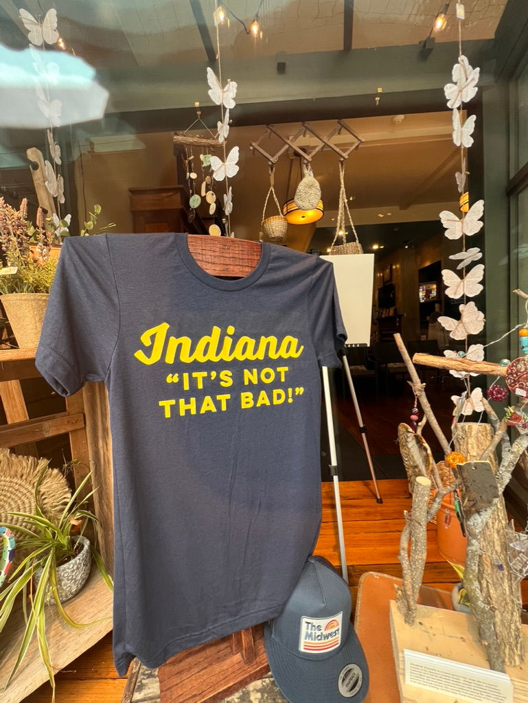
There are two States in America that have somewhat of an inferiority complex -- Indiana and Kansas -- and I lived in both of them and learned about the dynamics.
Indiana. Indiana has somewhat of an inferiority complex (as confirmed by that t-shirt in the window) because it is located between Ohio and Illinois, as well as south of Michigan. Ohio has extensive frontage onto the Great Lakes; Illinois has a lot of frontage on Lake Michigan, and Chicago is the major railhead as the RRs concentrated there to get south of Lake Michigan while avoiding Canada; and Michigan itself is a peninsula. The frontage on the Lakes meant two things: (1) cheap transportation, and (2) hydro-power (mills, da…