Sedona
- Lucian@going2paris.net

- Jan 8, 2021
- 4 min read

Sedona, Arizona
January 8, 2021
Sedona /sɪˈdoʊnə/ is a city that straddles the county line between Coconino and Yavapai counties in the northern Verde Valley region of Arizona. As of the 2010 census, its population was 10,031. It lies within the Coconino National Forest.
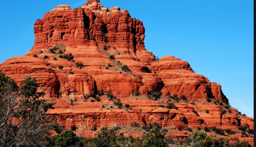
Sedona's main attraction is its array of red sandstone formations. The formations appear to glow in brilliant orange and red when illuminated by the rising or setting sun. The red rocks form a popular backdrop for many activities, ranging from spiritual pursuits to the hundreds of hiking and mountain biking trails.
Sedona was named after Sedona Arabella Miller Schnebly (1877–1950), the wife of Theodore Carlton Schnebly, the city's first postmaster, who was celebrated for her hospitality and industriousness. Her mother, Amanda Miller, claimed to have made the name up because "it sounded pretty".
History
Anglo-American settlement
The first Anglo settler, John J. Thompson, moved to Oak Creek Canyon in 1876, an area well known for its peach and apple orchards. The early settlers were farmers and ranchers. In 1902, when the Sedona post office was established, there were 55 residents. In the mid-1950s, the first telephone directory listed 155 names. Some parts of the Sedona area were not electrified until the 1960s.
Sedona began to develop as a tourist destination, vacation-home and retirement center in the 1950s. Most of the development seen today was constructed in the 1980s and 1990s. As of 2007, there are no large tracts of undeveloped land remaining.
Important early settlers included the Steele family, originally of Scotland.
Chapel of the Holy Cross
In 1956, construction of the Chapel of the Holy Cross was completed. The chapel rises 70 feet out of a 1,000-foot redrock cliff. The most prominent feature of the chapel is the cross. Later a chapel was added. Inside the chapel there is a window and a cross with benches and pews.
Cinematic legacy
Sedona played host to more than sixty Hollywood productions from the first years of movies into the 1970s. Stretching as far back as 1923, Sedona's red rocks were a fixture in major Hollywood productions—including films such as Angel and the Badman, Desert Fury, Blood on the Moon, Johnny Guitar, The Last Wagon, and 3:10 to Yuma. However, the surroundings typically were identified to audiences as the terrain of Texas, California, Nevada, and even Canada–US border territory.
The town even lent its name to the 2011 film Sedona.
Geography
West Sedona – Route 89A
Sedona is located in the interior chaparral, semi desert grassland, Great Basin conifer woodland biomes of northern Arizona. Sedona has mild winters and warm summers.
According to the United States Census Bureau, the city has a total area of 19.2 square miles, of which 0.04 square miles, or 0.22%, is water.
Flora
Sedona interior chaparral has many shrubs and small tree species of Quercus turbinella, Rhus ovata, and a large population of Quercus palmeri. The Great Basin woodland has many small to medium trees of Pinus monopylla Var. fallax, Juniperus arizonica, Juniperus deppeana, Juniperus osteosperma, Juniperus monosperma, a large population of Cupressus glabra. At higher elevations in oak creek canyon Juniperus virginiana, Pinus edulis, and other pines occur.[17][18]
Geology
The red rocks of Sedona are formed by a unique layer of rock known as the Schnebly Hill Formation. The Schnebly Hill Formation is a thick layer of red to orange-colored sandstone found only in the Sedona vicinity. The sandstone, a member of the Supai Group, was deposited during the Permian Period.
Climate
Sedona has a temperate semi-arid climate. In January, the average high temperature is 57 °F with a low of 31 °F. In July, the average high temperature is 97 °F with a low of 64 °F. Annual precipitation is just over 19 inches.
Demographics
Historical population
Census Pop. %±
1970 2,022 —
1980 5,368 165.5%
1990 7,720 43.8%
2000 10,192 32.0%
2010 10,031 −1.6%
2019 (est.) 10,339 3.1%
As of the census of 2000, there were 10,192 people, 4,928 households, and 2,863 families residing in the city. The population density was 548.0 people per square mile. There were 5,684 housing units at an average density of 305.6 per square mile. The racial makeup of the city was 92.2% White, 0.5% Black or African American, 0.5% Native American, 0.9% Asian, 0.1% Pacific Islander, 4.3% from other races, and 1.6% from two or more races. 8.9% of the population were Hispanic or Latino of any race.
At the 2000 census there were 7,229 people living in the Yavapai County (western) portion of the city (70.9% of its population) and 2,963 living in the Coconino County (eastern) portion (29.1%). By land area Yavapai had 66.2% of its area, versus 33.8% for Coconino.
There were 4,928 households, out of which 15.8% had children under the age of 18 living with them, 48.6% were married couples living together, 6.6% had a female householder with no husband present, and 41.9% were non-families. 32.2% of all households were made up of individuals, and 14.2% had someone living alone who was 65 years of age or older. The average household size was 2.06 and the average family size was 2.52.
In the city, the population was spread out, with 13.7% under the age of 18, 4.5% from 18 to 24, 21.2% from 25 to 44, 35.0% from 45 to 64, and 25.6% who were 65 years of age or older. The median age was 50 years. For every 100 females, there were 88.1 males. For every 100 females age 18 and over, there were 85.9 males.
The median income for a household in the city was $44,042, and the median income for a family was $52,659. Males had a median income of $32,067 versus $24,453 for females. The per capita income for the city was $31,350. About 4.7% of families and 9.7% of the population were below the poverty line, including 12.1% of those under age 18 and 5.0% of those age 65 or over.
Comments